Little Creek Mesa trail
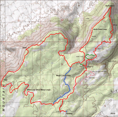
Of all of the mesa top rides in the area, Little Creek Mesa seems to offer the greatest variety of terrain. Curvy forest single track suddenly spits a rider out onto smooth undulating fields of slickrock that seem to appear out of nowhere and stretch to a horizon seemingly bounded by the west temple of Zion. The constancy of small sandstone obstacles interrupt the forrested flow but offer punchy and powerful counterpoints to the winding singletrack through the pinion and junipers. Yet as enjoyable as all that is, it is the cliff edge riding with its sense of space and stupendous views that most riders come here for.
Edges are often the most interesting places in nature, and riding a bike along the edge of an 80 foot cliff is no exception. Little creek offers long sections of edge riding along the north rim of the mesa with the trail diving into the trees as winding single track around roots and boulders, for variety. Both the main loop and the trail to the north point offer miles of jaw dropping views along a trail that requires constant attention for the small technical challenges that it presents. The sections of the loop that don’t follow the mesa edge twist and turn through the open plains of slickrock, where deceptive gulleys, draws, and small canyons determine the route, and create somewhat of a maze like feel. One long section of rolling slickrock dubbed the Magic carpet ride for its smooth undulations, is one of the highlights of this ride, and is best ridden in the return to the trailhead direction.
Little creek mesa trail is like a rural uncultured and ill-mannered cousin to the upscale and cosmopolitan Gooseberry mesa, with a sense of backwoods wildness that Gooseberry lacks. The entire trail system is marked with cairns of rock, which often require some searching and interpretation when the wind topples a critical one. New variations (marked the same manner) seem to spring up overnight and lure unsuspecting riders pushing the limits of daylight into harrowing thoughts of spending the night out on the endless slickrock, while retracing their path searching for the main trail, and the salvation of the trailhead parking.
Speaking of the trailhead, there really isn’t one. Just a point where the road becomes ridiculous and the trail begins. Don’t expect a parking lot, toilet, signs, maps or warnings about taking enough water and letting people know where you are. If the road didn’t degrade at that point there is no reason at all to suspect that it is in fact where you should park, and begin riding.
Little Creek is also the highest of the mesa top rides and remains wet and muddy when the others are bone dry. This elevation also makes winter snowfall less of a rarity than other destinations, and along with the amount of riding in the shade of the trees means less sun to dry things out and fewer ridable days than the lower elevations.
The directions to the “trail head” seem pretty reasonable in this era of google maps, but there are no signs at all, and after a few miles with no other vehicles in sight it is not uncommon to begin to imagine banjo music in the distance. The roads themselves are ok, and 2WD with some decent clearance is typically all that is necessary when they are dry. A layer of volcanic cinders was laid down a few years ago, and even when wet the surface seems to require far fewer tow truck calls than Gooseberry’s clay.
The spring wildflowers and cactus typically bloom in May, with a short season of Cedar gnats possible in late may to early June.
Wildlife is typical of the Colorado plateau, with a healthy population of rattlesnakes likely due to the abundance of water/rodents. The food chain is complete at places with this level of remoteness as represented by the occasional mountain lion track on the trail especially in the winter.
The Big Loop: This is the original ride on the mesa and winds through the trees, slickrock plains, rock gardens eventually arriving at the north rim. Best ridden clockwise, the ride intermittently follows the rim for a couple miles then back into the trees to avoid a major drainage before a T intersection that will either lead to the Magic carpet ride by turning right or the north loop on the left.
- 10 miles
The North loop: This loop will take in more of the north rim to the north point and around the edge of a large open canyon to huge plains of slickrock. Turning left at the intersection will offer a descent into a canyon, or right back to the T junction and Magic carpet ride.
- 4 miles
Difficulity: Advanced
Kid Friendly: NO
Dogs: Yes
Wet Weather ride: NO
% Singletrack: 100
Quality: ***** (1-5)
Website links:
Trailforks
Mountain bike project
Utah mountain biking.com