ATV and Jeep Opportunities
Southern Utah is becoming well-known as an off-road haven. Within a few minutes from St. George there are thousands of miles of dirt roads and, within a 90 minute drive, two major recreational state parks with open riding areas in beautiful pink and red sands. One of these state parks is even a mere 30 minutes from the center of St. George. In some smaller cities, you can still ride your ATV’s on designated streets to access the dirt roads, and in even smaller towns, you can ride on all public roads. Though this may seem like the wild west to the city dweller who is used to heavy restrictions on ATV’s, but many of these smaller townships are in farming and ranching intensive areas where ATV’s are used as ranch tools as much as for recreation. Research and follow the local laws BEFORE you ride in order to avoid legal issues and to keep these places open to our use. Yield to pedestrians and horses, obtain the proper permits and licenses and stick to the trails where required to.
Visitors to this part of Utah interested in getting out into these backcountry areas have the options of bringing their own vehicles, renting equipment from local sources, or taking a tour with a commercial company.
Rentals:
Several local companies provide rental equipment as well as advice on places to go and best routes of travel. Expect to provide a significant deposit as well as a requirement to be 21 years old to rent equipment.
Utah Power Toys: They rent side by side Razors and have a virtual location where they meet and provide the equipement: http://www.utpowertoys.com
Red Desert Rentals: From watercraft to ATV’s and RVs http://www.reddesertrentals.com
Southern Utah Adventure Center: Watercraft, Jeeps, Razors, ATV’s www.southernutahadventurecenter.com
Tour companies
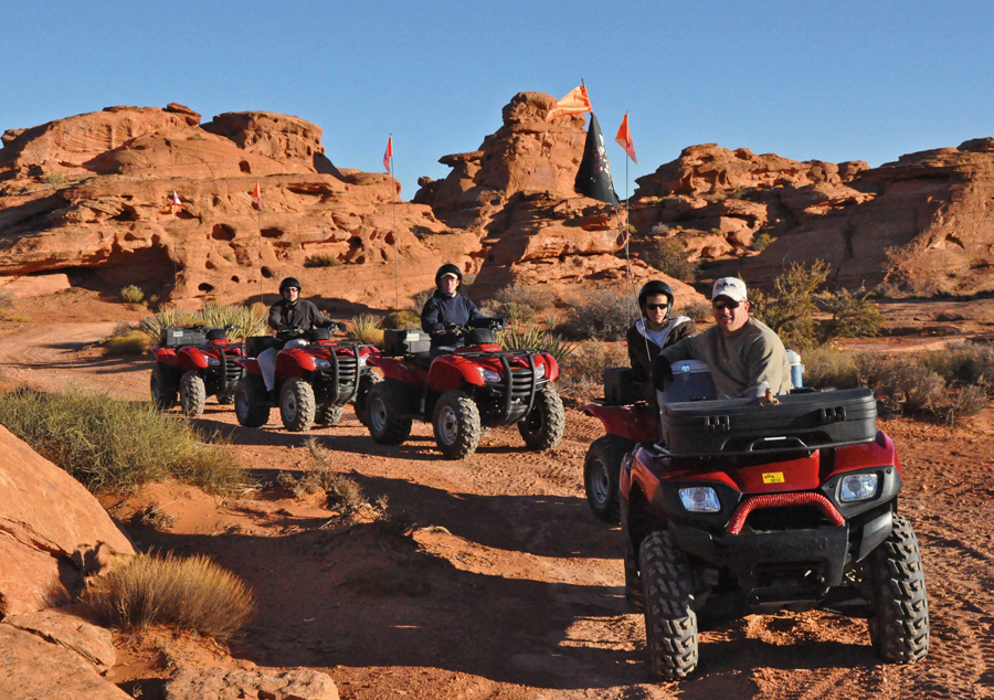
By far the easiest method of getting to see some of the most staggering backcountry areas in the region is to use one of the local commercial ATV and Jeep tour companies. They specialize in providing comprehensive training on the equipment used, know the best local places to ride, and provide guides who make it their business to ensure that visitors have a safe tour as well as the experience of a lifetime. This is also the most time efficient means of experiencing the amazing terrain of the region while on a vacation schedule that may have many constraints.
ATV and Jeep Adventures: The most established tour company in the region with 20 years of experience guiding people on a wide range of equipment and through an amazing array of scenery and landscapes. One of the best local tour companies of any disipline. http://www.atvadventures.com/
Riding through the Hoodoos on Sandstone Mountain with ATV and Jeep Adventures
Southern Utah Adventure Center: Located along state street in Hurricane, provide rentals as well as a wide range of tour options. http://www.southernutahadventurecenter.com
Places to Explore
Utah State Parks
Sand Hollow State Park
Utah’s newest State Park, Sand Hollow, features a man made reservoir with camping, fishing and boating opportunities. From the reservoir/camping area, you can access Sand Mountain to the south. These approximately 15,000 acres of majestic sand dunes allow open riding in soft red sand with gorgeous red rock out-croppings all around. At just 3,000 feet elevation, this is one of the warmest places to ride in the state. Zion Park is only 40 minutes away, making this one of the most visited state parks in Utah. Like many riding areas, there is a “comp hill” to test your vehicle and your nerves at tall hill climbing on the mountain’s south side. From Sand Mountain you can access the Arizona Strip BLM land to the south and east to explore wide open roads and rugged landscapes. Please check the link for fees, regulations and reservations.
Directions: From the I-15 freeway, exit the highway 9 towards Zion National Park (east). After approximately 5 miles, turn right (south) on Sand Hollow Road. Continue south on this road for approximately 4 miles, then turn left into the park entrance.
Coral Pink Sand Dunes
Like many places in Utah, the name describes the land exactly. These visually-striking coral pink colored sand dunes sit at 6,000 feet elevation, allowing you to ride amongst large trees and help avoid some of southern Utah’s summer heat. It has over 3,700 acres of land and 90% of this land is open for OHV riding. In the winter, enough snow stays on the ground here to allow some awesome winter tubing and sledding. With a different environment than Sand Hollow, this park is a great place for day hikes, especially good for stretching your legs after a long day of riding. Camping is available as well. Please check the link for fees, regulations and reservations.
Directions: From the Highway 89, take the highway 43 west. This highway is south of the highway 9 through Zion. The park entrance is on the highway 43.
Guides/Rentals: http://kanabwesternadventures.com/?page_id=5212
BLM Lands
The Bureau of Land Management manages two major areas near Saint George Utah: the Arizona Strip and the Beaver Dam Mountains. There are thousands of miles of roads and trails in each of these areas. Primitive camping is allowed in most BLM areas, but open riding is limited to certain areas and generally on established roads. Visit these lands to ride a wide range of open gravel roads through a variety of landscapes and environments as well as many rough 4×4 and high clearance trails.

Jim Clay pilots his Pinzgauer Jeep over slickrock on Sandstone Mountain
Arizona Strip
The Arizona Strip’s slogan is “Where the west stays wild.” This is a just description of this area, as there are no services, towns or anything out here. Though a part of Arizona, the nearest town with a spectrum of services is Saint George, Utah. The Arizona Strip is a 2 million acre section of land between the Grand Canyon and Utah and is home to over 5,000 miles of dirt and gravel roads and trails. The Grand Canyon itself isolates this huge piece of territory from the remainder of the state of Arizona, and one must drive around the canyon either east or west for access. Currently, this area is managed by the St. George Utah BLM office as it is much more easily accessed from Southern Utah. Landscapes , geology, elevations and ecosystems vary widely in this vast and empty area. You can find countless caves, canyons, slot canyons, cliffs and mountains here. A popular destination from these roads is the north rim of the Grand Canyon itself. With a Jeep or ATV, you can find access points to the Grand Canyon at many places inaccessible in any other type of vehicle. “Toroweap point is located within Grand Canyon National park and requires 50 to 75 miles of isloated gravel and dirt road travel for access. This unique part of the Grand Canyon is one of the few places where you can stand on the edge of a cliff and look straight down to the Colorado river. The difficulity of the access also offers the opportunity to enjoy relative solitude on all except the busiest weekends. This solitude comes with the necessity to be self reliant and prepared for the unexpected. Experienced jeep riders will bring extra gas, camping supplies, shovels, pick axes and sometimes even spare vehicle parts in case things break. Also, it is a common practice to travel in a caravan of two or more vehicles for safety.
Directions: We highly recommend purchasing and using maps when riding here. The Arizona Strip is so vast that it has several access points from Southern Utah. In Saint George, the two easiest points are to take River Road south until it turns into dirt, or take the Black Rocks Road exit east off of the I-15. In the city of Hurricane, off the highway 9, turn south on 700 West St. Then turn right (west) on 2060 South St. This road quickly curves and becomes 1100 West St. This road then turns into dirt BLM roads after approximately 4.3 miles.
Arizona Strip Field Office link:
Laws & where to ride link: Although the Arizona Strip is a federal Entity, they use the following AZ State Parks brochure for OHV use in the strip. Click the link to download this free pdf.
http://azstateparks.com/OHV/index.html
Beaver Dam Mountains National Conservation Area
This large 19,000+ acre portion of the BLM contains a wide variety of landscapes, geology and wildlife. It features limestone mountains, the Virgin River Gorge, Joshua tree-strewn deserts, as well as red rock hiking areas and the Bloomington Caves, as well as several scattered archaeological sites. Stay to the designated roads here as motorized vehicles are prohibited within designated wilderness areas. Hunters, hikers, wilderness therapy programs, rock climbers, shooters, rock hounds and even farmers and ranchers all use these roads as well so please be courteous and safe when riding.
Directions: This area is also extremely vast and has so many roads that a comprehensive guidebook is nearly unachievable. Please obtain maps for this area and choose your routes/access points wisely. We have shared some basic starting points, but please keep in mind that most of these dirt roads and access points are not marked.
From the I-15: Exit Littlefield/ Beaver Dam and head north along the old highway 91. As you pass through the Joshua tree landscape of the Mojave, watch for dirt roads that lead into the desert on your left and right.
From west St. George: Head west on Sunset Blvd, which becomes the old highway 91 after passing through Ivins and Kayenta. It will pass through the Shivwitts Paiute Reservation. While in the reservation there are two dirt roads that lead into these lands on the left and right. If you use these access points, stay on the road until you pass out of the reservation. Trespassing within the reservation is illegal. Continue on the highway 91 into the Beaver Dam mountains to find several other dirt roads. Some of these are old mining roads and some do not go very far. Many of these roads however, meet up with other access points along highways and can be followed for countless miles. Eventually, this highway crests over the Beaver Dam Mountains and leads you back to the I-15 freeway where our first set of directions took you.
Southeastern corner: exit Brigham Road, navigate the roundabout to head south along the frontage road: Pioneer Road. Turn Right (west) on Man of War Road. At the stop sign at South Bloomington Drive, turn left. Then turn left onto Navajo Drive. This road turns into dirt and eventually meets up with the old highway 91 and the rest of these dirt roads closer to the Beaver Dam Mountains.
Dixie National Forest
The Dixie National Forest spans 170 miles across southern Utah. The forest offers many miles of designated roads that would be suitable for ATV and Jeep travel. The elevations range between 3,000-11,000 feet, and like most national forests, allows a variety of recreational activities, like hunting, fishing, camping, hiking and even canyoneering. It also boasts 2,700 miles of trails designated for motorized travel! Due to increase in popularity, off-road travel is prohibited, so stay to the roads and trails. Like the BLM lands, there are many access points to these trails and roads in several cities. Please see the paragraphs below for details.
Directions and where to ride: Click the link below for a complete pdf of the official Motorized Vehicle Use Map.
http://www.fs.usda.gov/Internet/FSE_DOCUMENTS/stelprd3798793.pdf
Cedar City, Powell & Escalante Ranger District Maps Link: Click the link below for other Forest Service map links. From this link, scroll down to find the list of the 2014 Motor Vehicle Use Maps with links to three other maps to different districts of this forest.
http://www.fs.usda.gov/detail/dixie/maps-pubs/?cid=STELPRDB5444281